
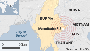
A magnitude 6.8 earthquake hit the Burmese border region on 24th March, following on from the magnitude 5.8 earthquake that Menas Borders reported on 11th March.
This most recent earthquake hit near the Burma-Laos-Thailand border region at approximately 8:25pm local time (1:55pm GMT), and had a magnitude of 6.8, according to the US Geological Survey.
Thailand's Meterological Department measured the quake as a magnitude 7, and reported a magnitude 5 quake hitting about half an hour later. The US Geological Survey did not report that quake, but did report a 5.4 magnitude quake about two hours later.
The quakes were shallow, taking place about 6 miles underground on a small fault line on the Burmese-Lao border, according to Thailand's Mineral Resources Department. It was felt 800km to the south in the Thai capital Bangkok and in the Vietnamese capital, Hanoi.
Chinese news agency Xinhua says an official statement from Burma has reported that 74 people have been killed and 111 injured in the quake. It also said that 390 houses, 14 Buddhist monasteries and nine government buildings had been damaged.
The Burmese town of Tachileik in Shan state, which lies right on the border with Thailand, and near the tripoint with Laos, appears to have been the worst affected, although the Bangkok Post has reported that one woman was killed in Thailand's neighbouring Chang Rai province, when a concrete wall collapsed on her. In Lao, little damage and no casualties have been reported.
The deputy director-general of the Thai Meteorological Department, Somchai Baimuang, said that the earthquakes in Burma were a consequence of the Japanese quake causing movement of the tectonic plate in Burma.
On 10th March, a magnitude 5.8 earthquake struck near the Chinese -Burma border area.
Sources: BBC, Xinhua, Bangkok Post, US Geological Survey
For more information, please see the Menas Borders website, here.
No comments:
Post a Comment